• home icon
  • overview icon
  • data icon
  • environment icon
  • guidelines icon
  • guidelines icon
  • noise icon
  • topography icon
  • end icon

Seismic surveying is a vital part of exploring for oil and gas. That makes it critical to producing the energy we need to power our homes and businesses

overview icon Seismic Survey Overview

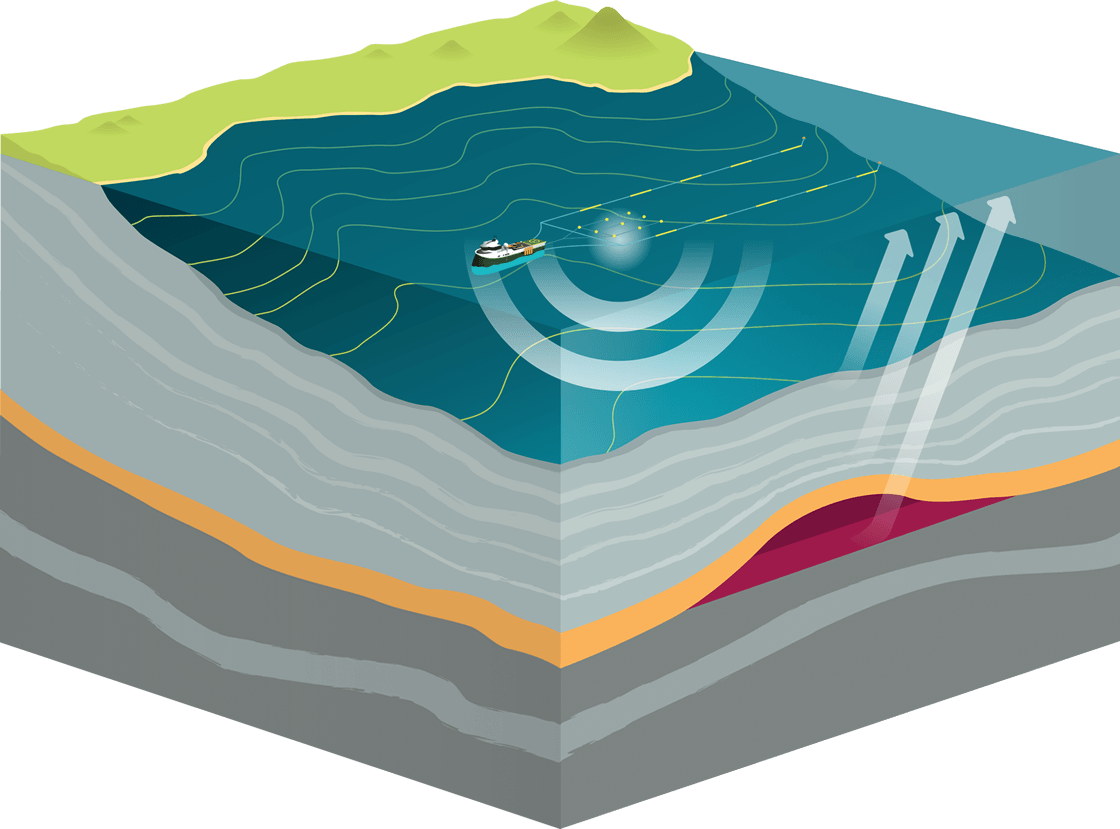
Seismic surveys produce detailed images of the various rock types and their location beneath the earth’s surface. This information can tell us the location and size of oil and gas reservoirs, without having to disturb the land or seabed.

Reflection seismology (or seismic reflection) is a method of exploration geophysics that uses the principles of seismology to estimate the properties of the Earth’s subsurface from reflected seismic waves.

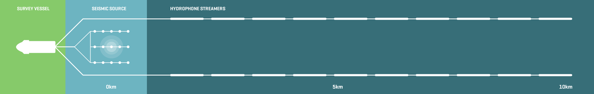
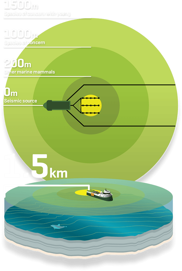
Seismic surveys involve an acoustic source that release bubbles of compressed air, these bubbles collapse and send a directionally focused low frequency sound wave towards the sea floor.

Source icon 
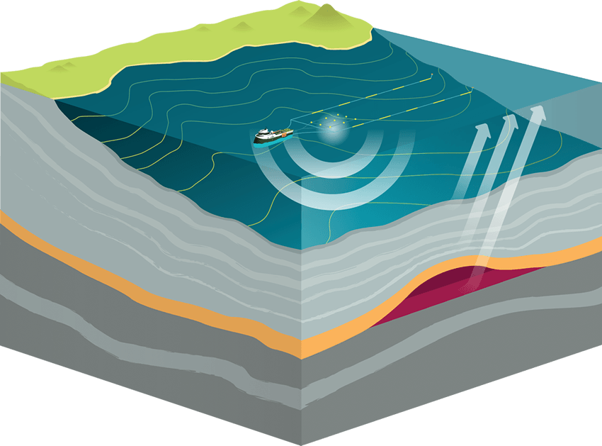
Sound waves are bounced off rock formations below the seafloor and the waves that reflect back to the surface are captured by recording sensors within the streamers of the seismic vessel.
The time it takes for each sound wave to return to the hydrophones provides valuable information about the depth of different structures and possible gases or fluids trapped in rock formations.
crossection of a seismic survey

Listen icon HYDROPHONE STREAMERS

The streamers towed behind the seismic vessel can be up to 10km long, and contain pressure sensitive devices called hydrophones. The hydrophones convert the reflected pressure signals and transmit back to the recording system on board the seismic vessel. Each streamer is solid and filled with neutrally buoyant foam.

diagram survey vessel seismic source and hydrophone streamers
data icon

data icon DATA COLLECTION

Seismic data acquisition involves applying a seismic energy source at a surface location. The resulting energy is reflected back from interfaces where rock properties change.

Seismic data must then be interpreted by geophysicists. The results produce detailed understanding of the underlying geology.

onshore icon

Onshore

The acoustic energy source for onshore seismic survey operations is either small explosive charges placed in shot-holes (commonly 10-50 m deep) or by specialised trucks that carry a heavy plate which is vibrated. Both of these methods send sound waves beneath the earth’s surface and listening devices called geophones are placed on the surface nearby to capture the returning sound waves.

marine icon

Marine

A specialised seismic vessel tows from one up to ten streamers depending on whether it is a 2D or 3D seismic survey. Acoustic sources use compressed air to produce acoustic energy sending sound waves towards the seabed. The hydrophones within the streamers capture the returning sound waves.

Collection icon

Collection icon DATA PROCESSING

Once data has been collected it must be interpreted by geophysicists. The results are compared with other data to enhance the accuracy of the reading. This often produces detailed understanding of underlying geology to depths of more than 10km.

seismic data collection process

Geophysicists use geological mapping software to create 2D and 3D geological maps of an exploration site. This process is called ‘Geomodelling’. Software developers have built several packages for geologic modeling purposes. Such software can display, edit, digitise and automatically calculate the parameters required by engineers, geologists and surveyors.

environment icon ENVIRONMENTAL IMPACT OF SEISMIC SURVEYING

Seismic surveying is an established science with strict requirements and operational procedures set in place to ensure marine habitats remain undamaged by exploration activities. The oil and gas industry uses extensive environmental management plans to ensure all operations are conducted safely and responsibly.

BACKGROUND

After more than four decades of seismic surveying and countless research projects (both in New Zealand and world-wide) there is no clear evidence that sound from exploration activities in normal operating circumstances has permanently harmed marine mammal species.

TECHNOLOGY

Technological developments have provided much better detection of marine mammals that are not visible on the surface during seismic surveys, allowing explorers to conduct environmentally responsible marine seismic operations.

TECHNOLOGY: PASSIVE ACOUSTIC MONITORING SYSTEMS

Passive acoustic monitoring systems (PAM) are designed to detect the presence of marine mammals (whale, dolphin and porpoise) during seismic operations. This allows explorers to implement mitigation measures that minimise the potential impact of man-made sound.
Unlike visual observations, which are constrained by animals being at the surface, available daylight hours and sea/weather conditions, PAM can operate 24 hours-per-day and in more extreme conditions. It provides industry confidence that vocalising cetaceans in the vicinity of night time operations can be accurately and reliably located and tracked.
PAM observation is undertaken 24/7 during seismic surveys.

guidelines icon GOVERNMENT SAFETY GUIDELINES FOR SEISMIC SURVEYING

Offshore seismic surveys must adhere to the Department of Conservation’s (DOC) Code of Conduct for minimising acoustic disturbance to marine mammals.

OPERATORS UNDERTAKING A SEISMIC SURVEY ARE REQUIRED TO:

Have present two independent trained marine mammal observers and two passive acoustic monitoring operators. Record all observations/sightings of marine mammals before and during operations. Have regard to the mitigation zones. 1.5km radius for species of concern with young, 1km for species of concern without young, and 200m for all other species. The acoustic source must be stopped if any marine mammals enter the relevant mitigation zones. Use the lowest practical acoustic source volume for the survey that will still achieve survey objectives. Conduct 30 minutes of pre-observation prior to commencing the soft-start procedures, which slowly builds up the source volume over a period of 20 minutes.


Under the Code there are three mitigation zones for surveys, determined according to the sensitivity of the marine mammals to which they apply and the potential effect of the sound levels likely to be encountered at that distance from the source. The diagram opposite outlines the key distances.
  • Level 1: the highest power surveys, generally used by the oil and gas industry for exploration.
  • Level 2: less powerful surveys, often used for scientific research by NIWA and GNS
  • Level 3: includes all other small-scale seismic surveys – with noise levels less than commercial shipping – and is not covered by the provisions of the Code

Species icon MĀUI’S DOLPHIN: SPECIES OF CONCERN

As New Zealanders we need to protect the Māui’s dolphin from real threats that may cause a further decline in population.

The Māui’s dolphin is the world’s rarest marine dolphin, with fewer than 100 left in the wild. The subspecies is found in inshore waters on the west coast of the North Island, commonly within about five nautical miles of the shore.

Scientific information indicates that petroleum exploration or mining activities have not been cited to have any adverse effects on the Maui Dolphin. Oil and gas exploration operations can be managed to minimise and effectively avoid adverse environmental effects, which includes marine mammals, and it is for this reason that the current Marine Mammal Sanctuary still allows petroleum exploration.


THREATS TO MAUI’S DOLPHINS INCLUDE:

  • Disease
  • Pollution from discharges into the coastal marine area
  • Plastic debris generated from dumping of both urban and marine based waste
  • Impacts associated with interactions between the dolphins and vessel operations
  • Permitted and non-permitted tourist vessels

Noise icon HOW LOUD IS A MARINE SEISMIC SURVEY

The sound from seismic surveying is comparable to many naturally occurring marine sounds – including those made by animals themselves.

FREQUENCY

Frequency is the number of times per second, that a sound wave cycles from positive to negative to positive again. Frequency is measured in cycles per second, or hertz (Hz). Humans have a range of hearing from 20 Hz (low) to 20,000 Hz (high). Frequencies beyond this range exist, but they are inaudible to humans.

AMPLITUDE

Amplitude (or intensity) refers to the strength of a sound wave, which the human ear interprets as volume or loudness.

background image

Topo icon WHY DO WE NEED TO USE SEISMIC SURVEYS?

Here in New Zealand we have 18 sedimentary basins – with only one of those basins (Taranaki) currently producing oil and gas.

By conducting seismic surveys (both onshore and offshore) we are able to get a better understanding of what kind of petroleum potential lies beneath our land and seas – without a huge environmental effect.

NEW ZEALAND'S SEDIMENTARY BASINS

New Zealand's main oil, gas and coal resources are contained in onshore and offshore sedimentary basins. These Cretaceous-Cenozoic basins cover about 1.7 million square kilometers.
A sedimentary basin is an area where the Earth’s crust has subsided (sunk) and a thick layer of sediment has accumulated over millions of years.
Examples of active sedimentary basins include inland river valleys, lakes, gravel out wash plains and the undersea continental margins.

The oil and gas industry here in New Zealand currently employs 7,500 kiwis nationwide, contributing billions to our national economy and providing energy security for kiwi households.

And that is just from one of our basins.


By exploring what lies beneath the 17 other petroleum basins, the oil and gas industry may be able to grow the number of kiwis it employs, the financial contribution it makes to the country and provide more energy security to households and businesses.